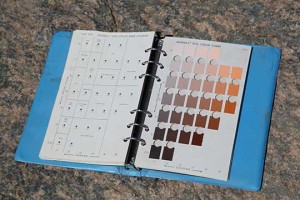
Munsell Soil Readings
By Dr. Rubén G. Mendoza, PhD
Description: The documentation and interpretation of archaeological stratigraphy – or natural and cultural soil horizons or layers — is a key variable in the study of context and relationships in an archaeological site. In order to properly describe each layer or strata pertinent to an archaeological site, it is necessary to first properly document and map the strata in question. In order to do this, archaeologists and geologists quite typically make use of the Munsell Soil Color Chart in order to conveniently measure and compare soils colors with the color chart in question. Today’s exercise will require that you make use of the Munsell Soil Color Chart to take soils “readings” from the excavation areas currently under study.
Deliverables: The outcomes and deliverables sought from this exercise require that you produce soil readings at those intervals specified below, and that you provide both the Munsell color name and relative hue and value indicated.
Instructions: The following considerations and procedures should be taken into account when conducting the (a) soil readings, and (b) corollary granular and crumb structure comparisons:
1. First, your group or team should select one of the few Munsell rock or soils charts made available by your project supervisor. Having selected either the rock or soils chart, please proceed to undertake the following procedure:
2. Second, if you have selected the Munsell Soil Chart, you are to designate at least one person to record results, one person to facilitate the soils chart comparisons and interpretations, and one other person to collect samples. The following basic procedure should guide sample collection:
○ Using the north or northwest unit wall profile (or other available profile where the north or northwest profile is unavailable), mark the strata with nails or wooden pegs or skewers at 10 centimeter intervals from the surface to the base of the existing unit.
○ Upon marking the unit profile, use the tip of your trowel to collect dry samples of soil no more than about the size of an American quarter (coin) from each of the 10 centimeter intervals so marked by nails or skewers.
○ Compare the soil color (dry) to the pages within the Munsell Soil Color Chart and narrow down the range of variation to that that approximates the color of the soil collected from the soil strata first sampled.
○ Having determined the Hue or Munsell number indicated in the upper right-hand corner of Munsell chart page selected, you are to compare the specific soil sample selected to the chart color on the page noted by holding the trowel full of soil beneath the circular windows in the chart.
○ Select the Value indicated in the chart page by noting the number indicated on the left-hand portion of the chart. The Value lightens from the bottom to the top of the page and this co-varies with the larger the number indicated for the lighter the value.
○ Finally, determine and record the Chroma indicated at the bottom of the chart which varies from grey on the left to heightened Chroma or color on the right.
3. Third, employing the same soil samples, use the available spray bottle to moisten the sample and thereby prepare a Wet version of each sample for each stratum as per same procedure for Dry samples noted above. Finally, use the Granular and Crumb Structure pages of the Munsell to record related data.


